Chapter 4 of 17 · Water and the Weather
Chapter 3. How a cloud forms
What a cloud is made of, why it stays up, the four ways of making one, and how what we see in the sky is named.
Water that can at last be seen
To look at a cloud is to look at water that has stopped being invisible. Nothing more, and that is already a great deal: the previous chapter established that air cooled to its dew point releases its surplus vapour in liquid form. A cloud is exactly that result, brought about not on a kitchen window but in a body of air in the open atmosphere.
Météo-France puts it plainly: "clouds form by condensation of water vapour, that is to say by the passage of the water they contain from the gaseous state to the liquid state". And the same service describes what they hold: "clouds are formed of fine water droplets and ice crystals in suspension".
Two words in that last sentence deserve to be underlined straight away. Droplets and crystals: so liquid and solid, never gas. In suspension: so carried, not resting. This chapter explains how that water forms, why it stays up in the air, and how a name is given to what we see.
The objectives of this chapter
Each one is observable. By the end of the chapter, either you do it, or you know which section to read again.
- Say what a cloud is made of, and in which states the water is found in it.
- Name the four ways in which air cools enough to form a cloud.
- Place a cloud in one of the three levels, giving the order of magnitude of the height of its base.
- Recognise the main families of cloud in the sky from their shape and their height.
- Work out, from a description of a relief and a wind, the place where a cloud is going to form.
What this chapter assumes is already known
Two prerequisites, both installed by earlier chapters of this volume: the states of water and the name of condensation on the one hand, saturation and the dew point on the other.
Why a cloud does not fall
A cloud holds a considerable quantity of water, and yet it floats. The contradiction is only apparent, and it comes down to the size of the droplets.
The droplets of a cloud are so small that the air slows them down as much as they weigh. A cloud droplet does come down, but so slowly that the least upward movement of the air is enough to hold it up, or even to carry it back up. Now the air of a cloud is precisely air on its way up: it is that rise which cooled it and which brought the cloud into being.
It is therefore not that the droplets do not fall: it is that they do not fall fast enough to leave the cloud. The next chapter will show what happens when they finally grow, and what changes then.
Nor are those droplets born out of nothing. The previous chapter named the condensation nuclei, those tiny particles suspended in the air, dust, sea salt, pollen or soot, on which the vapour settles: without them, air that is saturated all the same condenses very poorly. A cloud is therefore water resting on dust, and that is also why there is no cloud without an atmosphere carrying fine particles.
Remember this image, which will be taken up again: a cloud is not a tank sitting in the sky, it is a flow. Humid air comes in at the bottom, water condenses inside it, and part of it evaporates again at the edges. A cumulus that seems motionless for ten minutes has in fact renewed a good share of its contents.

The four ways of cooling air
Since a cloud is born of a cooling, it is enough to know how air cools in order to know where and when clouds form. Météo-France distinguishes four mechanisms, and they cover almost all the clouds we see.
Before setting them out one by one, the cause that recurs in three of them deserves to be stated, because it is not obvious: rising cools air, not because it would be joining colder air, but because pressure falls with height. Météo-France writes it thus: "as it gains height, a body of air sees its pressure fall, which cools it (compressing a gas warms it, expanding it cools it)". Air that rises therefore expands, and that expansion cools it from the inside, whatever the reason that makes it rise.
The first is convection. According to Météo-France, "the air present near a warm ground is warmed on contact with it and expands. Being lighter, it rises into the atmosphere before cooling at height". This is the mechanism of summer afternoon cumulus: the ground warms up, columns of air rise, and cauliflower-shaped clouds appear above fields and towns.
One remark is called for here, because it explains half the cloud patterns we observe: not all surfaces warm up at the same rate. Ploughed earth, a roof, a road heat quickly and strongly under the Sun, whereas a body of water, lake or sea, warms much more slowly and stays cooler as the day goes on. Convection therefore starts over land and not over water: that is why, on a summer afternoon, one often sees cumulus above the coast and a clear sky above the sea, a few hundred metres apart.
The second is orographic lifting, that is to say lifting by the relief: "when a body of air is pushed by the wind towards a relief, it is forced to rise along the slope". The air has no choice, it rises, so it cools, so it condenses. That is why a mountain so often carries its own cloud, and why the slope facing the wind is the wet slope.
The third is frontal lifting, which takes place at weather fronts, that is to say at the boundaries between two bodies of air of different temperatures. The warmer air, being lighter, slides up over the colder air and cools as it rises. This mechanism makes the great cloud sheets that cover a whole sky for a day.
The fourth is cooling from below: "when a body of mild air moves over a colder surface". Here the air does not rise, it is the ground or the sea that takes its heat away. This is the mechanism of fogs and low layers, and it links directly to the previous chapter.
The words to remember
Three words of mechanism, and one word of nomenclature that is used from the next section onwards.
- Convection
- The movement by which air warmed on contact with a hot ground expands, becomes lighter, rises and cools at height. It is the engine of fair-weather clouds and of thunderstorms.
- Orographic lifting
- The forced ascent of a body of air pushed by the wind against a relief. It cools the air without any heat from the ground coming into play, by the constraint of the slope alone.
- The genus
- The first level of the international classification of clouds. There are ten genera, and a cloud always belongs to one and only one of them. The genus is determined by the shape of the cloud and by the height of its base.
- The level
- One of the three vertical bands into which clouds are sorted: the high level, the middle level and the low level. A cloud is sorted according to the height of its BASE, never of its top.
Ten genera, three levels, and a nomenclature shared by the whole world
Naming a cloud is not a game of erudition. It is what allows an observation made in one village to be understood on the other side of the planet, and that is why the nomenclature is international. The reference document is the International Cloud Atlas of the World Meteorological Organization, which writes that "examination of the most characteristic cloud forms brings out ten genera". Météo-France gives the same count: "clouds are classified into 10 genera according to their shape and the height of their base".
The names are built from a few Latin roots, and knowing how to read them is worth more than knowing how to recite them. Cirrus means a lock of hair, so a cloud in filaments. Cumulus means a heap, so a cloud with rounded outlines. Stratus means a spread-out layer. Nimbus means rain. Alto marks the middle level, and cirro the high level.
These roots combine, and the combination can be read: a cirrostratus is a layer of the high level, an altocumulus is a heaped cloud of the middle level, a nimbostratus is a layer that gives rain, a cumulonimbus is a heaped cloud that gives rain. Four names, none to be learnt by heart, all of them deducible.
The International Cloud Atlas states that "the troposphere may be divided vertically into three levels: the high level, the middle level and the low level", and that the heights of those levels depend on latitude. The troposphere is the low layer of the atmosphere, the one that touches the ground and in which everything this volume describes takes place: it is there that the clouds, the winds and the rain are. A cirrus is not at the same height above Greenland and above the Congo, and the table below says so.
| Level | Polar regions | Temperate regions | Tropical regions |
|---|---|---|---|
| High level | From 3 to 8 km | From 5 to 13 km | From 6 to 18 km |
| Middle level | From 2 to 4 km | From 2 to 7 km | From 2 to 8 km |
| Low level | From the surface to 2 km | From the surface to 2 km | From the surface to 2 km |
| Genus | Abbreviation | Level | What is seen |
|---|---|---|---|
| Cirrus | Ci | High | White, fine filaments, separate, with no shading of their own. |
| Cirrocumulus | Cc | High | Very small white elements in banks or in rows, with no shading. |
| Cirrostratus | Cs | High | A whitish, transparent veil, which lets the Sun through. |
| Altocumulus | Ac | Middle | Grey and white rolls or pebbles, in banks, with shaded parts. |
| Altostratus | As | Middle | A greyish sheet covering the whole sky; the Sun shows through it as through frosted glass. |
| Nimbostratus | Ns | Middle | A thick grey layer, without relief, which hides the Sun completely: the cloud of steady rain. |
| Stratocumulus | Sc | Low | Grey slabs or rolls, often joined together, with dark parts. |
| Stratus | St | Low | A uniform, low grey layer; it is the one that gives fog when its base touches the ground. |
| Cumulus | Cu | Low | Detached clouds with sharp outlines, white at the top, with a horizontal and darker base. |
| Cumulonimbus | Cb | Low | An enormous mass with a low dark base, whose top rises very high and spreads out into an anvil. |
The cumulonimbus, the giant of the table
One genus deserves to be set apart from the others, because its dimensions have nothing in common with theirs. Météo-France describes the cumulonimbus like this: "this giant, threatening cloud, 5 to 15 km wide, can rise to 15 km in height at our latitudes".
Compare that with the table of levels. At temperate latitudes, the high level runs from 5 to 13 kilometres: a cumulonimbus therefore crosses all three levels in one piece. It is nevertheless classified in the low level, and that is where the rule of classification takes on its full meaning: a cloud is sorted at the height of its BASE, not of its top. The base of a cumulonimbus is low, often less than a kilometre up.
Two genera carry the root nimbus, the root of rain, and they are the ones that give most of what reaches the ground. The general word for everything that falls out of a cloud, rain, snow or hail, is precipitation, and the next chapter is devoted to it entirely; a shower is a brief and intense precipitation, which begins and stops abruptly. The nimbostratus gives steady, even rain over a wide area; the cumulonimbus gives showers over a narrow one. The other genera may let fall trails of water or ice that evaporate before reaching the bottom.
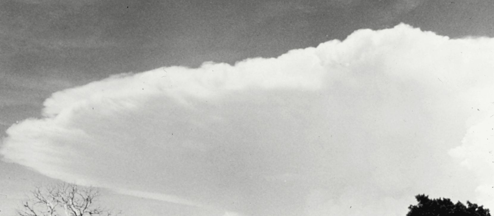
The trap of this chapter: reading the colour of a cloud as an omen. A cloud looks dark from below simply because it is thick and lets little light through; it is dazzling white from above at the very same moment, as any photograph taken from an aeroplane confirms. A uniformly grey sky can therefore stay dry all day, and a sky that is still blue can receive a shower within the hour if a cumulus develops quickly. Colour tells you about the thickness of the cloud, not about what is going to fall. What really tells you is the genus, and above all the speed at which it changes.
Worked example. Finding where the cloud is going to form
Question: "A steady wind off the ocean pushes humid air towards a range of hills. The sky is clear above the sea." Where are clouds going to appear, and on which slope does it rain the most? Example guided up to the next-to-last step.
- Identify the mechanism at work
The question gives a wind, humid air and a relief. That is the very definition of orographic lifting: "when a body of air is pushed by the wind towards a relief, it is forced to rise along the slope". - Follow the air up the slope
The air meets the first slope and rises. As it rises, it expands, since pressure falls with height, and that expansion cools it. As it cools, its maximum capacity to hold vapour falls, exactly as in chapter 2. - Find the height at which the cloud appears
At a certain height, the air reaches its dew point. It is there, and not before, that condensation begins: the cloud therefore has a sharp base, at roughly the same height all along the range. That is what gives relief clouds their strikingly horizontal base. - Carry on down the other side
Past the crest, the air comes back down. As it comes down it warms, its maximum capacity rises again, and the droplets evaporate once more. The cloud therefore breaks up above the far slope. - Over to you: say on which slope it rains the most
You know which side the air goes up, which side it comes down, and where condensation takes place. Name the wet slope and the dry slope, then check it in the answer to the self-check, question 5.
Experiment 4. Keeping a sky notebook for ten days
What you need: a notebook, a pencil, and a window or a yard. No equipment. SAFETY: this experiment is carried out with an adult's agreement, and the adult is present. It calls for going outside or standing at a window: it is the adult who chooses the spot, and an observation is never made from a ledge, a balcony without a rail or a roof. Never look straight at the Sun, even through a thin cloud.
- Prepare the page of the notebook
Draw a table with four columns: the date, the time, the share of sky covered, and the dominant genus. One page is enough for ten days. - Fix the time and the place, once and for all
Choose a time and a spot with the adult, and change them no more. An observation made every day at the same moment and from the same point can be compared; an observation made at random compares with nothing. - Estimate the share of sky covered
Divide the visible sky mentally into eight equal parts and count how many parts are taken up by cloud. Write the result down out of eight. This is the method observers have used for a very long time, and it calls for no instrument at all. - Name the dominant genus
Use the table of the ten genera. Ask yourself two questions in this order: is the cloud heaped, layered, or in filaments? Is its base low, middle or very high? The two answers give the genus in almost every case. - Also write down what you cannot name
Then write the shape in words, with no Latin name. An honest notebook is worth more than a complete one: after ten days, the descriptions you were unable to name will often sort themselves out. - Read it again after ten days
Look for whether the most overcast days carry the same genera, and whether one genus always comes back the day before a change. You will prove nothing with ten days, and that is exactly what this record teaches: a regularity shows up over seasons, not over a week. The chapter on climate will come back to this.
What to remember from this chapter
- A cloud is formed of fine water droplets and ice crystals in suspension: liquid and solid, never gas.
- The droplets are so small that the upward movement of the air is enough to carry them: a cloud does not fall because it does not fall fast enough.
- Four mechanisms cool air enough to form a cloud: convection, orographic lifting, frontal lifting and cooling from below.
- Air that rises cools by expansion: pressure falls with height, and expansion cools a gas just as compression warms it.
- The international classification counts ten genera, spread over three levels, and a cloud is sorted at the height of its BASE.
- The Latin roots can be read: cirrus the filament, cumulus the heap, stratus the layer, nimbus the rain, alto the middle level, cirro the high level.
- Two genera bring rain all the way to the ground: the nimbostratus, in a layer and steadily, and the cumulonimbus, in showers and in violence.
Self-check for chapter 3
Answer in writing, using only the knowledge given by this volume so far. The answers are gathered at the end of the volume.
- A cloud holds a considerable mass of water and it does not fall. Explain why, in two sentences at most.
- On a summer afternoon, cauliflower-shaped clouds appear above the land and not above the neighbouring lake. Name the mechanism and justify the difference, then cite the three other ways in which air can cool enough to form a cloud.
- Without looking at the table, break down the names altostratus and cumulonimbus, and say what each piece tells you.
- The cumulonimbus can rise to fifteen kilometres and yet it is classified in the low level. Why?
- Take up the worked example of the sea wind and the hills again: name the wet slope and the dry slope, and say what happens to the cloud past the crest.